

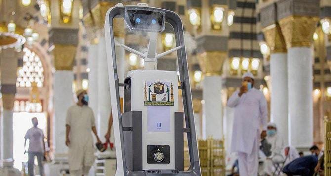
The General Presidency for the Affairs of the Two Holy Mosques has unveiled an advanced smart interactive map system, marking a significant leap in the use of technology to improve the experience of visitors and pilgrims in the sacred precincts.
This initiative aims to facilitate the movement of worshippers while simultaneously enhancing safety standards and operational efficiency within the haramain. By providing real-time guidance and dynamic routing, the system ensures that the massive flow of pilgrims can be managed effectively, reducing congestion and optimizing the overall spiritual experience.
According to Engineer Ghazi Al-Shahrani, Chief Executive Officer of the General Presidency, the smart mapping system represents a landmark advancement in service provision for the visitors of the holy mosques. He emphasized that the platform is designed to assist pilgrims at every step of their journey within the sacred sites.
Through real-time updates, the system not only offers directions but also recommends alternative pathways when temporary closures or unusual crowding occurs. This feature ensures the smooth movement of large numbers of people while maintaining the highest levels of safety and order.
The project, initially rolled out as a pilot during the month of Ramadan 2026, integrates a combination of “color coding” to indicate zones and “metric addressing” to segment the haramain into clearly defined areas. Dr. Mohammed Al-Saqr, Vice Executive President of the Digital Transformation Sector, explained that this zoning system allows for precise management of pilgrim flow. Each section is monitored to ensure that both foot traffic and vehicle movement are streamlined, which helps to prevent bottlenecks and manage crowd density effectively.
The mapping system has been designed with scalability in mind, with plans to introduce additional functionalities throughout 2026. These enhancements will include the integration of new features and tools to further improve operational effectiveness and support the General Presidency’s ongoing efforts to maintain high standards of service for the pilgrims. The system is being continuously updated with new data to ensure that it adapts to evolving crowd patterns and operational requirements.
Currently, the platform includes over 950 key points distributed across 13 service categories, each linked to more than 650 QR codes. This structure allows pilgrims to access essential services efficiently and navigate the haramain with ease.
One of the system’s most notable capabilities is the automatic generation of over 100,000 dynamic routes. These routes are updated continuously based on real-time crowd density and flow, allowing for optimal navigation throughout the complex. By leveraging this capability, the administration can ensure that pilgrims are directed along the safest and fastest paths, minimizing wait times and enhancing overall satisfaction.
Engineer Wahib Al-Mutrafi, Director of the Business Solutions Department at the General Presidency, highlighted another key benefit of the system: its ability to integrate geographic alerts and reports. These alerts allow administrators to monitor movement patterns, detect anomalies, and respond to emergencies quickly.
Furthermore, pilgrims can use their ticket numbers to access electric vehicles for easier mobility, improving access for those with limited mobility or other needs. By relying on accurate field data collected over months, the system provides a reliable platform for managing both routine operations and emergency situations.
The implementation of the smart interactive map system reflects the Presidency’s commitment to using digital solutions to improve operational efficiency while providing a high-quality service experience. Pilgrims benefit from both guidance and real-time decision-making tools, enabling them to navigate the sacred sites more safely and efficiently.
Additionally, the system contributes to staff efficiency by providing precise location-based information, which supports rapid response to incidents and ensures that all services meet established standards of quality.
The system’s use of color-coded zones enables clear visualization of different areas within the haramain, allowing visitors to quickly identify service points, prayer areas, and major thoroughfares. Metric addressing, meanwhile, provides accurate geolocation data, enabling precise coordination among security personnel, service providers, and emergency responders. Together, these two features form a robust framework for managing the movement of millions of pilgrims simultaneously.
As a digital innovation, the platform not only improves daily operations but also supports the broader objectives of the General Presidency in advancing technology-driven management within the sacred sites. By integrating detailed mapping, QR codes, dynamic routing, and geographic alerts, the system establishes a new standard for operational excellence in large-scale pilgrimage management. The smart platform exemplifies how digital solutions can be applied to enhance both safety and convenience, offering a model that could be emulated in other high-density public spaces globally.
Moreover, the platform’s capability to generate and adjust routes dynamically ensures that pilgrims always have access to the safest and most efficient pathways, even during peak times. The administration can use this data to predict crowd movements, plan resource allocation, and implement preventive measures to avoid congestion or accidents. This proactive approach represents a major shift in how large-scale religious sites can be managed using modern technology.
The project also emphasizes accessibility and inclusivity, ensuring that pilgrims of all ages and physical abilities can benefit from the system. From elderly visitors to those with special needs, the mapping platform allows for equitable access to services, pathways, and transportation within the sacred precincts. This inclusive approach aligns with the General Presidency’s mission to serve all visitors with the highest levels of care, guidance, and support.
Furthermore, the integration of QR codes throughout the site allows pilgrims to quickly access information about services, facilities, and points of interest. Whether seeking guidance for prayer areas, ablution facilities, or transport services, visitors can rely on the platform to provide accurate, real-time information that enhances their experience and minimizes stress or confusion.
By utilizing months of meticulously collected field data, the system ensures that operational decisions are informed by accurate, up-to-date information. This data-driven approach enables the General Presidency to respond immediately to changes in crowd density, emergency situations, or service disruptions. The platform’s predictive capabilities also allow for better planning of pilgrim flows, resource allocation, and service deployment during peak periods such as Ramadan or Hajj.
In addition to improving movement and guidance, the system enhances safety protocols by allowing security personnel to monitor and manage crowd density more effectively. With detailed geospatial data, administrators can identify potential risk areas, implement preventive measures, and coordinate interventions in real-time. The platform’s integration with existing operational infrastructure ensures that safety, convenience, and service quality are all maintained at the highest possible levels.
Ultimately, the smart interactive map system represents a major technological milestone in the administration of the Two Holy Mosques. By combining advanced digital mapping, real-time monitoring, dynamic routing, QR code integration, and field-tested data, the General Presidency has created a sophisticated platform that significantly improves the pilgrimage experience. It reflects a commitment to innovation, safety, and service quality that reinforces Saudi Arabia’s position as a global leader in the management of sacred religious sites.
The long-term vision for the platform includes continuous updates, integration of new features, and expanded operational capabilities, ensuring that it remains adaptive to changing visitor needs and evolving patterns of pilgrim movement. With this system, the General Presidency for the Affairs of the Two Holy Mosques is setting a new benchmark for digital transformation, crowd management, and service excellence in sacred spaces.
Through this innovative initiative, pilgrims now benefit from a modern, safe, and efficient navigation system, allowing them to focus on their spiritual practices while the administration ensures their comfort, security, and well-being. This initiative exemplifies how technology can enhance traditional religious practices by providing modern tools to facilitate movement, communication, and operational coordination.